- Sign In
- |
- Sign Up
- |
- My Quote (0)
- |
- CART (0)
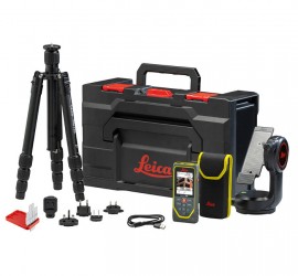
When it is mounted to a tripod using the DST 360-X adapter, the DISTO X6 is transformed into a Point-to-Point (P2P) measurement station, making the X6 the only LDM that can capture precise distance measurements in inaccessible areas or complex measurement situations.
When it is mounted to a tripod using the DST 360-X adapter, the DISTO X6 is transformed into a Point-to-Point (P2P) measurement station, making the X6 the only LDM that can capture precise distance measurements in inaccessible areas or complex measurement situations.
The connection of the DISTO X6 to sensitive sensors housed in the DST 360-X tripod adapter gives you access to precise angle and tilt data that it combines with its own laser distance and angle sensors to solve the trigonometry for Point-to-Point (P2P) measurements, even in inaccessible areas. Subsequently, the results can be downloaded as neatly organized DXF files for further processing in any CAD software. Additionally, visualization of the data in the DISTO Plan app on-site allows for immediate identification of any missing measurement points. This aids in the digitalization process, streamlines workflows, reduces costs, and mitigates errors.
Features
Applications
| Accuracy with favourable conditions | 1.0 mm (&frac116;") |
| Accuracy with unfavourable conditions | 2.0 mm (⅛") |
| Tilt measuring range | 360° |
| Range with favourable conditions | 0.05 to 250 m (0.07 to 820') |
| Tilt measuring tolerance | ± 0.2° |
| Range with unfavourable conditions | 0.05 to 150 m (0.07 to 500') |
| Measuring range with Leica DST 360-x horizontal | 360° |
| Smallest unit displayed | 0.1 mm (&frac;132") |
| Measuring range with Leica DST 360-x vertical | -64° to > 90° |
| Tolerance P2P function at distances | ± 5 mm / 5 m, ± 10 mm / 10 m |
| Laser | class 2, 635 nm, <1 mW |
| ø laser point | at distances | 6/30/60 mm | 10/50/100 m |
| Auto. laser switch off after | 90 s |
| Auto. power switch off after | 180 s |
| Memory | for 300 reports and 1/000 captured 3D points |
| Bluetooth® Smart | Bluetooth® v5.0 |
| Range of Bluetooth® Smart | up to 10 m |
| Battery durability (Li-Ion 2 000 mAh) | up to 4000 measurements, up to 8 hours operation time |
| Dimension (H x D x W) | 208 x 190 x 150 mm |
| Weight (with batteries) | 1580 g |
| Temperature range storage | operation (Applies to X6 device only.) | -25 to 70 °C | -10 to 50°C |